


Topics
Brush Management Currents Drought Educational Videos EduScape Guadalupe River Healthy River Incentives Landscaping Nature Based Infrastructure Riparian Areas River Corridor WatershedRiver Corridor
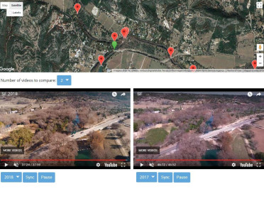
UGRA contracts the filming of aerial views of the North Fork, South Fork, Johnson Creek, and mainstem Guadalupe River to document changes in the watershed over time.
Aerial Videos of the Guadalupe River Corridor in Kerr County: 2011 - 2024
Learn MoreWhat is Your Watershed Address?
A watershed is the area of land that drains to a common creek or river. When it rains anywhere within a watershed boundary, water flows into the river and creeks and begins moving downstream. Knowing your location in the watershed and understanding what watersheds are upstream of you will help you understand your risk of flooding. In Kerr County, nearly all the land is within the Guadalupe River watershed.
Learn MoreEduscape
EduScape - UGRA's educational landscape
As you stroll along the landscape pathway you will see numerous examples of water conservation and stormwater detention practices that help stretch scarce water supply and protect all our water resources including the Guadalupe River. You can implement these same practices in your home or business landscape.
Featured practices include:
The Guadalupe River - Rainwater Harvesting - Texas Wildflowers - Pervious Surfaces
Dry Creeks - Lawns - Condensate Collection - Rain Gardens - Xeriscape
Learn MoreRiparian Areas
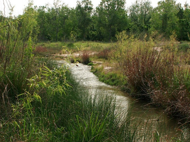
The riparian area is a band of dense, native vegetation along a body of water. This zone can be identified by high soil moisture, frequent flooding, and the unique collection of plants and animals found there. The distinct community of soil and vegetation form a network of roots and ground cover that intercept runoff from upland areas and stabilize the river bank. These areas also act like a sponge and have the capacity to store water for sustained release back into the river. As a result, riparian areas improve both water quality and quantity.
Learn MoreLow Impact Development
Low Impact Development (LID) is a land planning and design approach for managing stormwater runoff as close to its source as possible. LID principles complement, and sometimes replace, traditional stormwater management systems, which historically emphasized quickly moving stormwater off-site with curbs, pipes, and culverts. Stormwater runoff is the primary source of pollution into the Guadalupe River and waterbodies in general.
Learn MoreRecent "Currents" Articles
UGRA staff composes a monthly article on topics relating to the Guadalupe River, water quality, and state and local water issues and distributes it to the three local newspapers. View the most recent articles below
Learn More